Alaska
Keeping Alaska’s Busiest Port Open
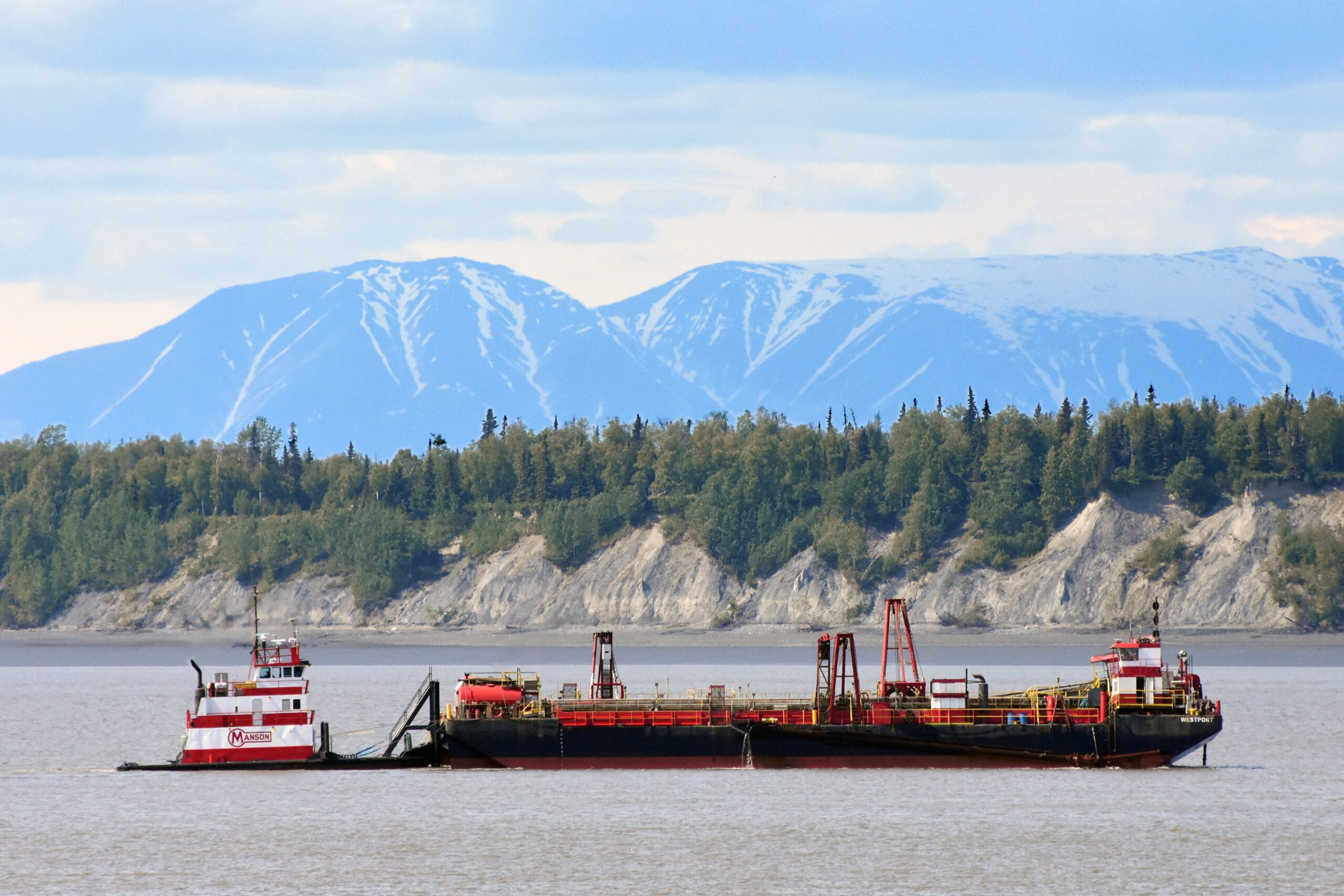
Visit Anchorage’s Port of Alaska in summer and you might notice a barge-like boat slowly plying the waters of upper Cook Inlet. Colored red and white, reminiscent of a candy cane, it has a boxy cabin on one end and a tugboat lashed alongside it. Beefy red arms angle out over the water from its open deck.
This is the 180-foot Westport, moving at an almost imperceptible speed as it continuously sucks up the mud – or more accurately, the glacial silt – that every day threatens to seal off Alaska’s busiest port. In summer, the boat may operate around the clock. Although dwarfed by the port’s buildings and stacks of containers, the humble Westport keeps this whole place running.
“I’m really proud of this rig,” says Donnie Johson, the Manson Construction superintendent for dredging at the port. From his office, he can see the Westport working in upper Cook Inlet.
Johnson, whose father also ran dredges, started dredging at eighteen. One of his first jobs was in the Pacific Northwest following the 1980 eruption of Mount Saint Helens. He’s now worked with the Westport for 30 years.
The ship, a “split-hull trailing suction hopper dredge,” is ideal for keeping the Port of Alaska open, says Johnson. It trails two big suction hoses with teeth that probe the seabed, loosening up compacted silt. The mud comes aboard and fills the hopper, an open space that can hold 2,000 cubic yards of material. When it’s full, two hydraulic rams open the split hull to dump the silt into deeper water.
“We suck up the mud, drive it across the bay, then dump it,” says Johnson. “Then we do it all over again.”
A simple task. But without it, the port would quickly become inaccessible to the steady flow of barges, cruise ships, military transports, and giant cargo ships bringing goods and fuel to Alaska. According to Port of Alaska director Steve Ribuffo, who has overseen port operations for a decade, half of Alaska’s ocean-bound cargo comes through the port. From oranges to ottomans and trucks to trampolines, it’s all loaded onto barges, trains, trucks, and airplanes for delivery to people and businesses statewide. The goods reach 85 percent of Alaskans.
The port’s pipelines and storage tanks also supply refined petroleum to Anchorage’s international airport, gas stations across Alaska, and the state’s military bases. Recognizing these vital roles, the port is one of only 18 federally designated strategic seaports nationwide.
But for all its importance, the port sits in a gnarly spot. Upper Cook Inlet hosts some of the biggest tides on Earth, with currents that can bully a cruise ship or cargo vessel. Winds and careening blocks of winter sea ice add more challenges. Captains must also keep watch for endangered beluga whales, which can affect operations. And the whole place is susceptible to earthquakes and tsunamis.
“It’s way above the average set of circumstances,” Ribuffo says with a short laugh. “Any port around the world might have one of these challenges, but we have them all.”
And then there’s the mud. The massive Susitna and Knik rivers, among others, pour into Cook Inlet, opaque with glacial silt from the mountains that form the port’s backdrop. The tiny grains, which glaciers like the Knik and Matanuska perpetually grind from the surrounding mountains, remain suspended in the rivers until they reach Cook Inlet, where slower currents let them to settle into mudflats, which are then further shaped by the tides.
“It’s an annual certainty that we need to dredge,” says Ribuffo.
The 1958 Rivers and Harbors Act and other laws require the port’s shipping lanes be maintained at 35 feet deep, a task delegated to the U.S. Army Corps of Engineers, which contracts the work to Manson Construction. The Corps is also heavily involved in a port modernization project that will move the docks further into the inlet, which may require less dredging.
The federal role, says Merlin Peterson, a hydraulic engineer with the Army Corps of Engineers, also requires surveying changes in the mudflats twice each week in summer. A boat accompanying the Westport conducts the surveys using multibeam sonar, which Peterson says can gather “many thousands of points,” which are condensed into maps that the Corps shares with the port and shippers.
The surveys also end up on Donnie Johnson’s desk. He analyzes them for how the changing shoals affect shipping lanes or areas alongside the docks, keeping in mind the tankers that he says “come in heavy” with Alaska’s fuel needs. Johnson also checks the week’s tides, which can change water levels by over 40 feet in just six hours. He then colors in the high spots he wants the Westport to trim down.
Two captains run the Westport, says Johnson. Traveling at just one-third of a knot, they switch duties hourly to maintain operations and stay alert. Three other crew run the tug and the nearby survey boat.
“There’s lots of opportunities for accidents,” says Johnson. “And it’d be horrible if someone ended up in the water, especially at night.” He adds that the crews train for safety and wear personal locator satellite beacons in case of an emergency in the inlet’s strong, murky currents.
Many of Johnson’s co-workers have been with the employee-owned Manson for years. He says that they enjoy good relations with the port and the shippers who steadily bring Alaskans the stuff that surrounds our daily lives.
“There’s a lot of trust there,” says Johnson.
Disclaimer: This story is auto-aggregated by a computer program and has not been created or edited by Worldtravelers.
Publisher: Source link
Publisher: Source link


Latest Posts
-
 31 July 2025
 -
 26 July 2025
 -
 14 July 2025
 -
 01 July 2025
 -
 07 August 2025
 -
 29 July 2025
 -
 20 February 2025
 -
 04 February 2025
Get The Best Blog Stories into Your icountox!
Sign up for free and be the first to get notified about new posts.