Michigan traveling
Michigan Trail Tuesday is our attempt to showcase a different trail or trail segment each week. The Mitten State is home to thousands of miles of trails, including the new Iron Belle Trail that runs from Detroit in the southeast to Ironwood in the western Upper Peninsula and more miles of the North Country Trail than any other state.
Pictured Rocks National Lakeshore is home to more than 100 miles of trails that lead to waterfalls, cliff-top views, Lake Superior beaches, sand dunes, and more. The hike to the Au Sable Point Lighthouse is a relatively easy one as it travels on a wide path for 1.5 miles. Along the way you’ll get some great views of Lake Superior and even the chance to see a couple shipwrecks. In the summer months, you can even take a tour of the lighthouse and climb its tower before you hike back. Your hike to the lighthouse begins at the Hurricane River day use area.


The Hurricane River day use area and campground is located just off of H-58, around 12 miles west of Grand Marais. The trail passes by the campground’s lower loop and its 12 rustic campsites. These sites are among the park’s most popular and they book up fast! After that the hike continues on a flat, well-maintained trail/road (occasionally used by NPS staff working at the lighthouse). Lake Superior is visible through the trees for almost the entire hike, and the only sounds other than the lake and other hikers will be the birds singing from the trees.


Around a half mile before reaching the lighthouse, a sign points to the beach and two shipwrecks. Here in the sand and shallow water are the intertwined remains of the Sitka and the Gale Staples. Both ships were wooden double-decked freighters built in the 1880s and around 270 feet long. The Sitka sank near here in 1904, and the Gale Staples in 1918. Years of taking a beating from Lake Superior have made it hard for National Park Service to distinguish the pieces of the two wrecks from each other. This is a great example of why a lighthouse at Au Sable Point was badly needed.


You can follow the beach from the wreckage and take the steep climb up once you reach the lighthouse, or retrace your steps back to main trail for the last half mile of the journey.


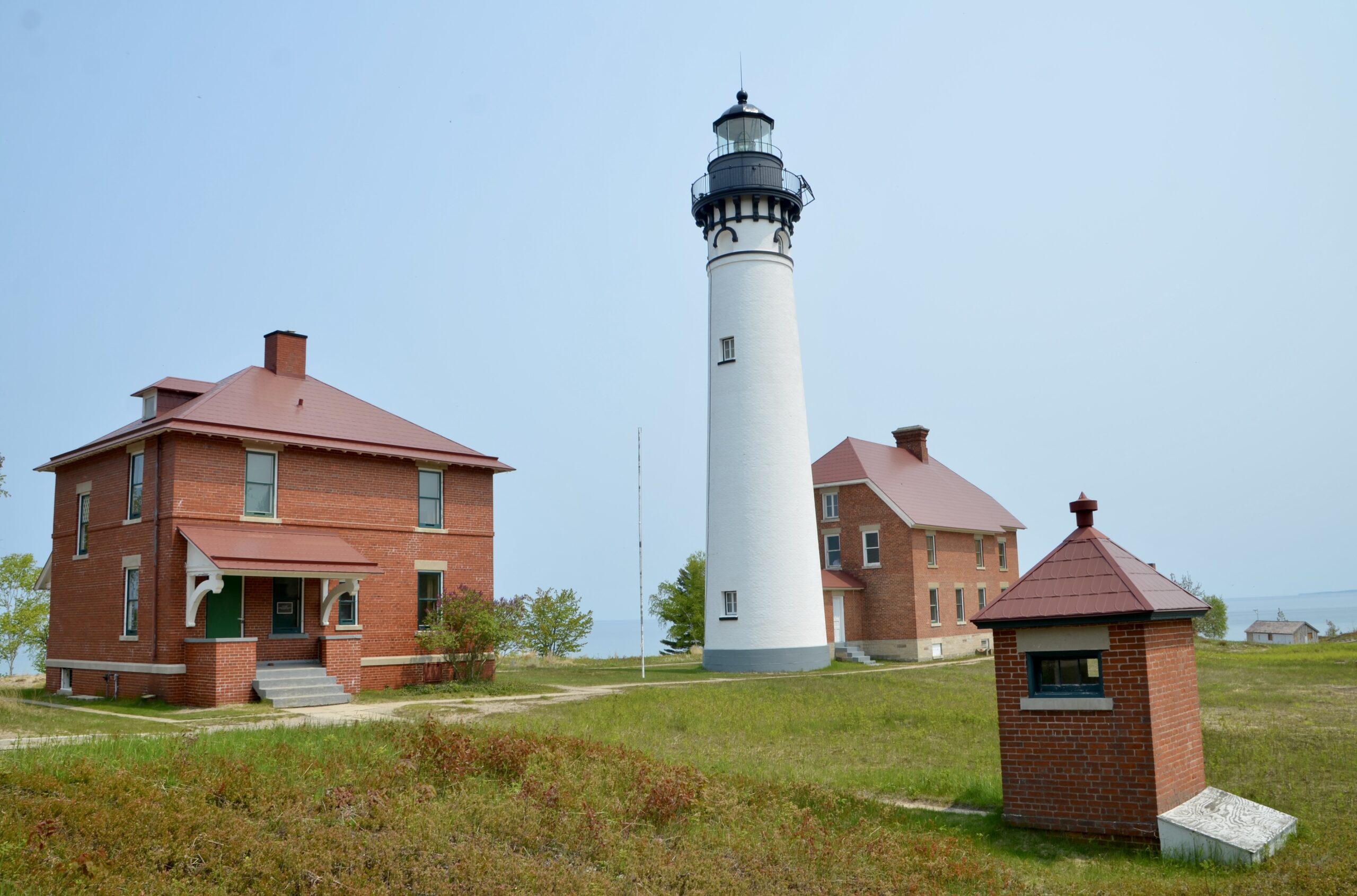
The Au Sable Point Lighthouse was constructed in the 1870s and is one of several Michigan towers designed by engineer Orlando Metcalf Poe. Its tower stands 86 feet tall and next to it is a brick keeper’s house building. Other buildings at the station that were later added and survive today are a second keeper’s house, storage shed, garage, fog signal building, and a brick outhouse. From June to September, NPS rangers are on hand for guided tours.


The views from here are incredible. To the east you can see the towering Grand Sable Dunes, and looking into Lake Superior from here shows how shallow the water is near the lighthouse.


The walk back follows the same route, and when you get back to the day use area it is a great spot for a picnic or relaxing at the beach. Don’t miss the small but scenic waterfall just upstream from the footbridge!
Disclaimer: This story is auto-aggregated by a computer program and has not been created or edited by Worldtravelers.
Publisher: Source link
Publisher: Source link

Latest Posts
-
 31 July 2025
 -
 26 July 2025
 -
 14 July 2025
 -
 01 July 2025
 -
 07 August 2025
 -
 29 July 2025
 -
 20 February 2025
 -
 04 February 2025
Get The Best Blog Stories into Your icountox!
Sign up for free and be the first to get notified about new posts.